
Parcel intelligence platform
ParcelMetric turns USA-wide parcel data into real-time intelligence.
Replace fragmented parcel workflows with a single platform for ingestion, normalization, data quality checks, analytics, and GIS exports. Start by integrating with your current GIS stack, or run ParcelMetric as the primary platform for data quality, governance, and change intelligence.
National parcel coverage
Change detection + alerts
Exports and APIs
Coverage
USA-wide
Always-on monitoring.
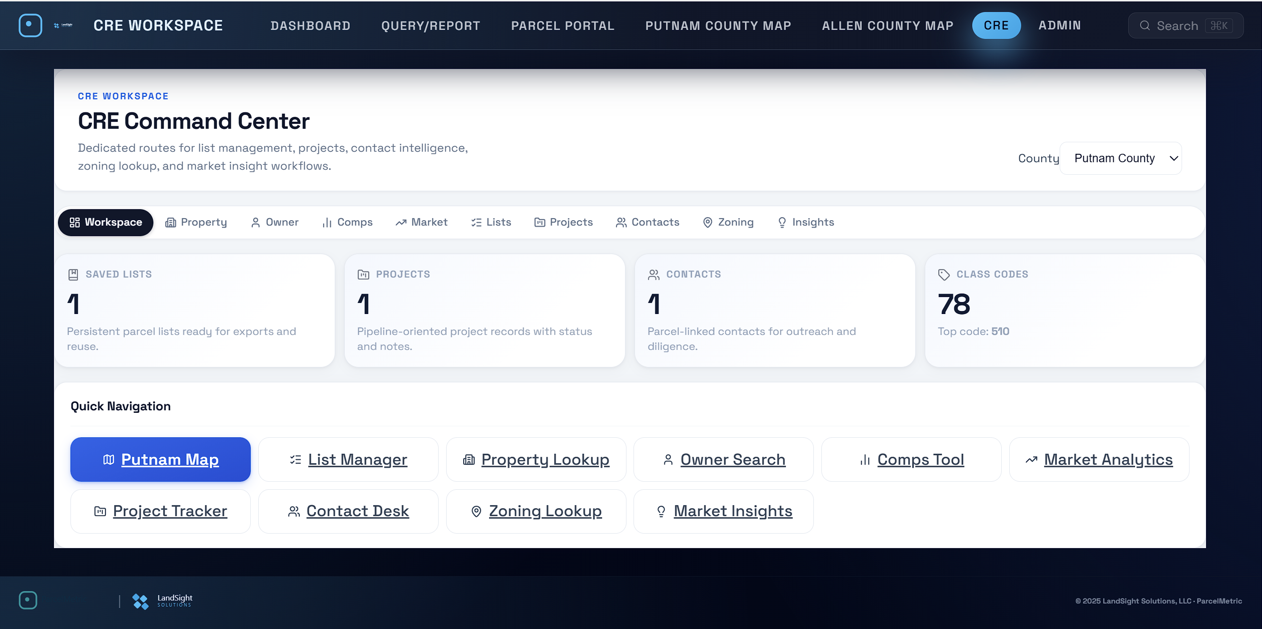
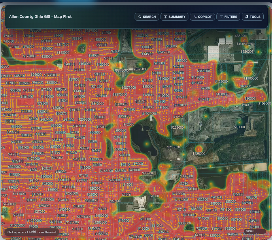
App + web views
Modern parcel workflows across desktop and mobile.
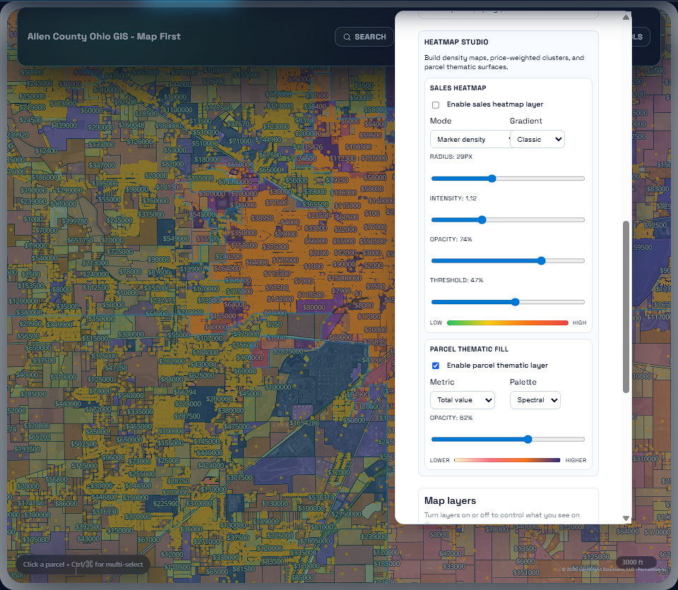
ParcelMetric delivers a clean, map-first experience with parcel search, ownership insights, data quality alerts, and change intelligence.
Field-ready insights
Give teams a fast way to review parcels, validate changes, and export GIS-ready data anywhere.
Visit ParcelMetric.com →Application tour
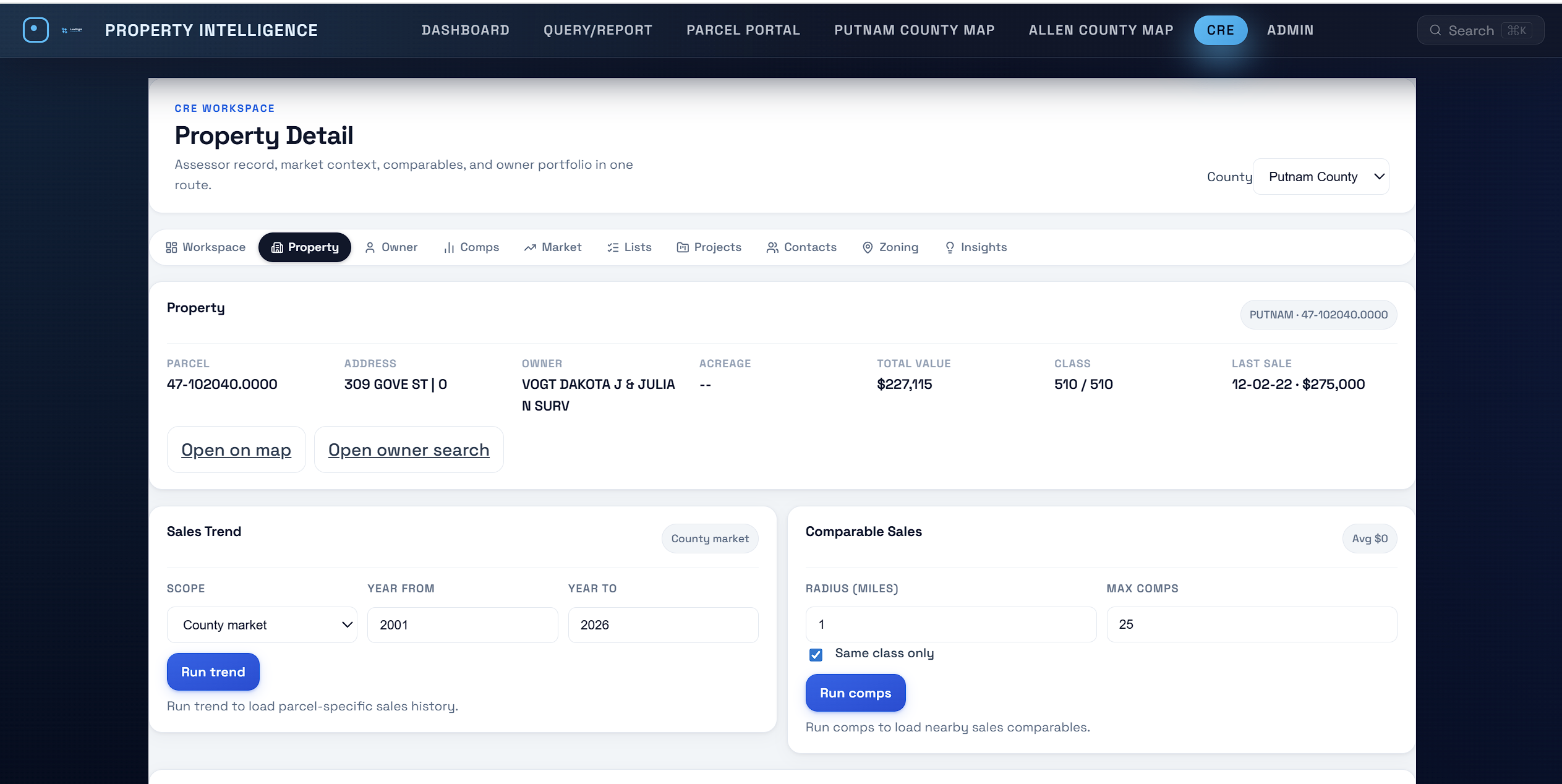
ParcelMetric components, connected in one interface.
ParcelMetric brings parcel search, ownership history, data quality checks, change intelligence, and GIS exports into a single workspace your team can use every day.
Feature suite
AI-first workflows for parcel programs.
Build a modern parcel intelligence stack with tools that ship outcomes fast.
Automated checks that detect anomalies and prioritize review.
Continuous monitoring for boundary, ownership, and attribute shifts.
Audit-ready parcel history and governance at every stage.
GIS-ready datasets for Esri, QGIS, PostGIS, and APIs.
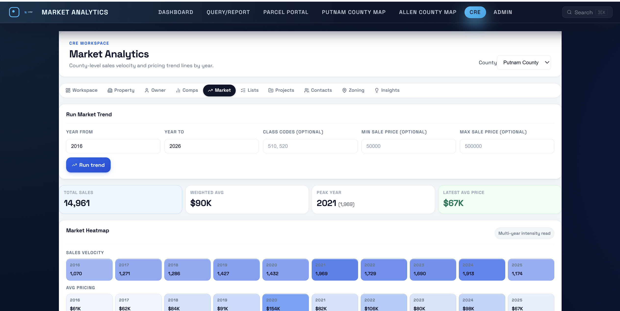
Product preview
A modern interface for data quality, change review, and delivery.
Instead of stitching together spreadsheets, scripts, and one-off GIS exports, ParcelMetric gives teams a single place to validate parcels, review change events, and publish GIS-ready outputs.

Automated data quality workflows
Run data quality checks continuously and route exceptions to review with audit-ready change logs.

Change intelligence
Detect boundary, ownership, and attribute changes, then prioritize and summarize what matters.

GIS exports + APIs
Publish outputs to ArcGIS, QGIS, PostGIS, and downstream systems with consistent schemas.
AI intelligence
AI-assisted data quality and change detection.
ParcelMetric blends automation and AI to surface parcel anomalies, flag inconsistencies, and prioritize changes that matter most to decision-makers.
AI modules
Purpose-built intelligence for parcel programs and enterprise portfolios.
- Anomaly detection across assessor feeds
- AI-assisted data quality workflows
- Automated change summaries
Platform modules
Everything your parcel program needs in one platform.
Configure the modules you need and scale into a complete parcel intelligence system.
Ingestion + normalization
Automated data intake from assessor sources with consistent parcel schema.
Data quality + verification
Rules-based data quality checks, geometry checks, and audit-ready verification.
Change intelligence
Continuous monitoring for boundary, ownership, and attribute changes.
GIS exports
GIS-ready datasets, API access, and integration with Esri and open-source stacks.
Portfolio analytics
Executive dashboards for land holdings, risk exposure, and performance KPIs.
Governance
Access control, audit trails, and data lineage for compliance-grade operations.
Built for scale
ParcelMetric supports counties, states, and enterprise portfolios.
Whether you are aligning a tax roll, building a statewide parcel program, or managing a national portfolio, ParcelMetric scales to your mission with automation and governance built in.
Core outcomes
Move from manual parcel maintenance to trusted, automated intelligence.
- Faster parcel change audits
- Reduced GIS operational overhead
- Transparent data lineage for decision-makers
Implementation
Deployment in weeks with a dedicated GIS partner.
We guide your team through discovery, integration, and ongoing optimization.
Data onboarding
Align parcel schemas, ingest assessor feeds, and configure automation rules.
Workflow enablement
Train GIS teams, configure dashboards, and launch decision-ready analytics.
FAQ
ParcelMetric questions, answered.
Can ParcelMetric replace our existing GIS parcel workflows?
Yes. ParcelMetric can integrate with existing GIS stacks, and it can also become the primary system for data quality, governance, and change intelligence, replacing manual and legacy parcel maintenance where desired.
Can we use ParcelMetric for statewide parcel programs?
Yes. ParcelMetric is designed for statewide parcel coverage with consistent data quality.
How does ParcelMetric handle parcel change detection?
We monitor assessor feeds and validate parcel changes with automated rules and audit trails.
See ParcelMetric live
Book a demo tailored to your GIS workflows.
We will walk through parcel change intelligence, automated data quality checks, and GIS-ready outputs.